How are sky positions given? Altitude, azimuth, RA and declination
Positions in the sky are usually given in two coordinate systems. Altitude and azimuth say which direction to face and how high to look from where you are right now, while right ascension and declination give each star a fixed address on the sky itself. For naked-eye work, knowing that a fist at arm's length covers about 10 degrees is enough to estimate altitude quite well.
Altitude and azimuth: coordinates from where you stand
Altitude is the angle of an object above the horizon. The horizon is 0 degrees and the zenith, the point directly overhead, is 90 degrees. An object below the horizon has a negative altitude and cannot be seen. Halfway between horizon and zenith, at 45 degrees, is roughly where your gaze goes when you tilt your head halfway back.
Azimuth is the direction along the horizon. It is usually measured from true north, increasing toward the east, so east is 90 degrees, south 180 and west 270. Some fields measure it from the south instead, so it is worth checking which convention a table uses. An object at azimuth 135 degrees and altitude 30 degrees, for example, lies to the southeast, about three fists above the horizon.
 ▶ Open in the simulator
 Why altitude and azimuth never stay still
Because altitude and azimuth are tied to your own horizon, they are intuitive, but they do not last. Earth turns 15 degrees an hour, so stars rise in the east and set in the west and their altitude and azimuth change minute by minute. Measure the same star at 21:00 and again at 23:00 local time and you get two different answers.
They also depend on place. At the same moment, a star seen from London and from Sydney has a different altitude and azimuth in each city. Horizon coordinates therefore only make sense together with a time and a location, which is why star catalogues do not list them. They are ideal, on the other hand, for directions such as 'Jupiter, southeast, 20 degrees up at 22:00 tonight', which tell an observer exactly where to look.
Right ascension and declination: a star's address on the sky
The equatorial system extends Earth's equator and axis out onto the sky. The celestial equator is Earth's equator projected onto the sky, and declination is how far north or south of it an object lies: +90 degrees at the north celestial pole, −90 at the south, just like latitude on Earth. Two numbers, declination and right ascension, pin down a star the way latitude and longitude pin down a city.
Right ascension is measured eastward along the celestial equator and plays the role of longitude. Its starting point is the March equinox, where the Sun crosses the celestial equator heading north. Instead of degrees it uses hours, with 24 hours making a full circle, so one hour equals 15 degrees. Hours are convenient because the sky appears to turn once a day: a star one hour greater in right ascension crosses the meridian, the north–south line through the zenith, roughly one hour later. The right ascension of the Sun itself increases through the year, which is the coordinate-system view of why the evening sky changes with the seasons.
Why we need both systems
Right ascension and declination turn with the sky, so a star's values stay the same as Earth rotates. Star catalogues, charts and object databases all use them. Over very long spans the frame does creep: Earth's axis wobbles like a spinning top, a motion called precession that takes about 26,000 years per cycle, so coordinates are quoted for a reference date such as J2000.0.
At the eyepiece, though, what you need is which way to face and how high to look. Planning an observation means converting a star's catalogue address into altitude and azimuth for your latitude, longitude and time. In the Sky view, selecting Sirius shows its current altitude and azimuth on the card next to its right ascension and declination; change the time, and the altitude and azimuth move while the right ascension and declination stay fixed.
The bridge between them: the pole's altitude equals your latitude
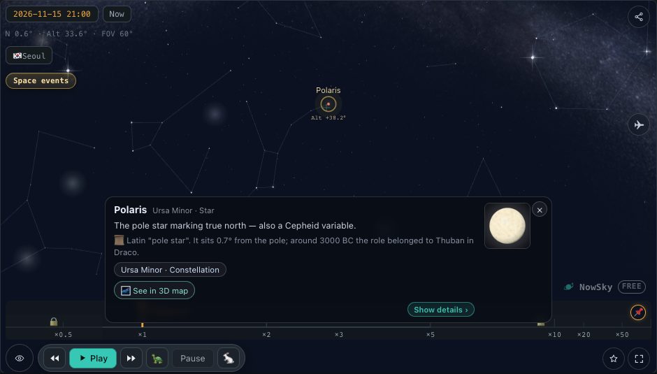
The two systems are linked by the observer's latitude. The celestial pole stands above the horizon at an altitude equal to your latitude. In the Northern Hemisphere, Polaris lies within one degree of the north celestial pole, so its altitude is a good estimate of latitude: about 51.5 degrees in London and 40.7 in New York. In the Southern Hemisphere there is no bright pole star, but the south celestial pole stands at about 34 degrees above the southern horizon from Sydney.
By the same logic, the celestial equator crosses the meridian at an altitude of 90 degrees minus your latitude: about 38.5 degrees in the south from London, and about 56 degrees in the north from Sydney. A star's highest altitude follows from its declination. Sirius, at a declination of about −16.7 degrees, peaks at only about 22 degrees from London, about 33 degrees from New York, but about 73 degrees from Sydney, high in the northern sky.
A fist is 10 degrees: measuring the sky by hand
You do not need a protractor for naked-eye work. With your arm fully extended, a closed fist covers about 10 degrees and the width of your little finger about 1 degree. The exact values vary a little from person to person; to calibrate your own hand, measure against a star whose altitude you already know.
With it, an altitude of 30 degrees is three fists above the horizon and the zenith is nine. The Sun and the full Moon are each about half a degree across, easily covered by a little finger. A Moon near the horizon looks larger than one high in the sky, but a finger held at arm's length shows that its size has not changed. From London, Polaris sits about five fists up; from New York, about four. Distances between stars can be measured the same way. Polaris lies about five times the gap between the two pointer stars at the end of the Big Dipper's bowl, so measuring that gap with your fingers turns it into a ruler for finding the pole star.
Try it in the simulator
- Polaris's altitude →Select Polaris and the altitude on its card closely matches your latitude.
- Compare Sirius's coordinates →Change the time: altitude and azimuth move, RA and Dec stay put.
- The Sun's altitude →Select the Sun for its current altitude, azimuth and transit time.
FAQ
- Is azimuth the same as a compass bearing?
- A magnetic compass points to magnetic north, which can differ from true north by several degrees. The difference, called magnetic declination, varies from place to place.
- Do planets have fixed RA and Dec?
- No. The planets, the Moon and the Sun move among the stars, so their right ascension and declination change from day to day. Only distant stars, nebulae and galaxies keep effectively fixed values.
- Can a star be seen at 0 degrees altitude?
- Near the horizon the atmosphere bends light, lifting objects slightly above their true position. In practice, buildings, hills and the thick air near the horizon make observing easier above about 10 degrees altitude.
Related reading
- Object Polaris
- Object Sirius
- Guide How do you find Polaris and true north in the night sky?
- Guide Which constellations can you see each season, and why do they change?
- Guide How do you read tonight's sky with the NowSky Sky view?